 |
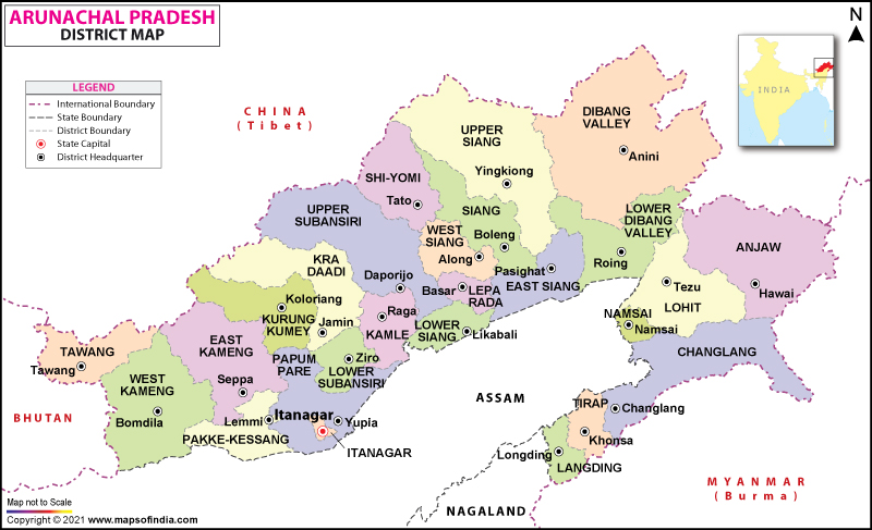
| Map of Arunachal Pradesh (Courtesy: MapsofIndia). |
I keep wondering about my own state. Very often it is funny and at the same time strange. Below are my random observations:
- Capital Cities: What in the world Itanagar was chosen as the capital city. It is located on a mountain top, on the extreme west of the state. For those from the east, it is difficult to access. I would think Pasighat is a better strategic location. Look at the headquarters of the Changlang District. It is too on the extreme end of the district. Just to get there is tough: not many transport services, the road is extremely rough, the lodge are difficult to get. Jairampur town is a better location which is in the center and has more access. So it seems to me the strategic decisions in Arunachal Pradesh are made at the whims and wishes of the stronger politicians or community.
- No Road to Criss-Cross the State: Assam is the only link. To travel to other districts of the state, without Assam, we are doom. When Assam declares a bandh, the whole state is paralyzed. Only recently, the initiative for the Trans-Arunachal Highway has been underway. Who knows how long it will take before we can move around the state freely.
- 100% Claimed by Outsiders: About 90% of the State is claimed by China or rather those are disputed areas. No wonder Arunachal people have no way to travel to China because China issues only stapled visa which India would not accept. The people are trapped, with no options. The other 10% is claimed by Naga groups. Recently, Eastern Naga Peoples Organization (ENPO) claimed Changlang and Tirap Districts to be part of their state. Where is Arunachal?
- Larger Refugee Population: Perhaps, Arunachal is the only Indian State where refugee population is very high. Most probably, Chakma forms as a largest single ethnic group after Nyshi, Adi and Apatani.
No comments:
Post a Comment